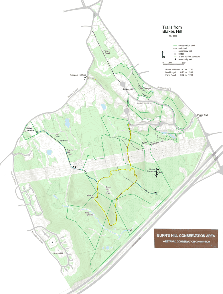
Westford’s newest big trail was constructed in the Burn’s Hill Conservation Area in 2014. The Burn’s Hill Loop Trail begins with a quarter-mile trail from Rome Drive to the power line, followed by a loop that is one mile long. It was conceived by Bill Harman, built by Eagle Scout candidate Sean Cheng, and supervised by Steve Smith and Ron Gemma. It climbs three hills, most notably Burn’s Hill, and it overlooks both the Vine Brook headwaters and a large marsh with an impressive heron rookery.
This trail was built to Appalachian Mountain Club standards. This means that in steep areas, you’ll find bench cuts and cribbing, or steps, all to ease the trail angle and to prevent erosion. Wet areas have carefully placed stepping stones or a simple bridge. This trail was built to last.
It crosses an old cart path in two places. This was likely used by local farmers to get their produce and goods to and from markets via the precursor to Route 110. With some care, you can follow this path to the southern edge of the large marsh, where a stone bridge crosses the outlet at a beaver dam. Which was built first, the path or the dam? It could be either. Another stone bridge, closer to Route 495, crosses Vine Brook. This can be accessed from the bottom of Burn’s Hill, following the height of land toward the highway. Halfway there, you’ll pick up a faint herd path, indicating repeated recent usage.
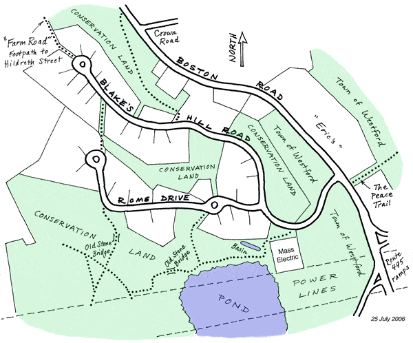
Two more substantial stone bridges can be crossed. The first is a few hundred feet from the trailhead on Rome Drive. A small side trail descends to a view of the foundation. The second, an elaborate but low stream crossing, is on the Kingfisher Trail.
The Kingfisher Trail heads southeast (left) from the first major Burn’s Hill Loop intersection. This starts on an old woods road, skirts the power line clearing just west of the marsh, reenters the woods, crosses the stone bridge mentioned earlier, and follows the northern edge of the marsh. It passes a difficult-to-follow side trail to the first Rome Drive rotary, and ends on Blakes Hill Road near the power substation.
But wait, there’s more! Two short trails take you all the way to Boston Road. Pass the end of the Burn’s Hill trailhead to the end of Rome Drive. Follow the steep uphill path between two rows of boulders, and you’ll end up on Blakes Hill Road. The trail appears to end a dozen yards from the road, but the easement continues to the hydrant. Take note of the trail sign and your surroundings for your return trip. It’s between houses 18 and 20. Then descend the road until a field opens up across from number 10. A sign directs you to the MacDougall Trail, which enters the woods through a metal gate. This trail was named for the family of Allister MacDougall, who ran a rope tow up Blakes Hill from 1955-1969. See http://www.nelsap.org/ma/blakes.html for some history and photos. This quarter-mile trail stays high for most of its length, then drops to Boston Road along the lower part of the old lift course. It terminates across from Mamie Lane, 200 feet north of Crown Road.
Finally, Farm Road is an old cart path that runs from the end of Blake’s Hill Road (between houses 15 and 28) to Hildreth Street. It begins near a pool fence and ends on a driveway, so please respect the property owner’s privacy.
See Hildreth Meadow for a separate description of the trail to lower Hildreth Street.
Location
The Burn's Hill Loop Trail begins with a quarter-mile trail from Rome Drive to the power line.Parking: Moderate
Trail Map

Click to zoom in or out
Topographic Map

Click to zoom in or out
Difficulty
 Moderate
Activities
- Hiking
- Birding
- Wildlife Viewing
