Stony Brook Subwatershed (excerpt from EOEA Merrimack River – A comprehensive Watershed Assessment Report, 2001)
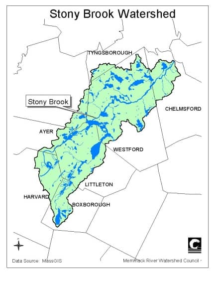
The Stony Brook Watershed is a 45 square mile area located in the southwest corner of the Merrimack River watershed (Figure 6). It is located entirely within the state of Massachusetts and encompasses all or parts of eight towns including Boxborough, Harvard, Littleton, Ayer, Groton, Westford, Tyngsborough, and Chelmsford. The brook originates at Wolf Swamp in Boxborough and flows for 22 miles to its confluence with the Merrimack River in Chelmsford.
The stream is known as Beaver Brook from Wolf Swamp to Forge Pond in Westford. Upon exiting Forge Pond, it becomes Stony Brook and remains so to its terminus at the Merrimack River. Communities in this watershed are primarily rural to suburban but are growing rapidly given their proximity to Routes 3 and 495. Residential and commercial development threatens the sensitive and highly productive aquifers in the region. Stony Brook and Beaver Brook are
Class B waters and must meet standards for primary (swimming) and secondary (fishing and boating) contact recreation as established by the Clean Water Act. Other waterbodies associated with Stony Brook in Massachusetts include Bennetts Brook, Gilson Brook, Black Pond,
Spectacle Pond, Mill Pond, Forge Pond, Boutwell Brook, Snake Meadow Brook, Keyes Pond, Keyes Brook, Burgess Pond, Long Sought for Pond, Flushing Pond, Blue Brook, Nabnassett Pond, Tadmuck Brook, Crooked Springs Brook, Cold Spring Brook, and Newfield Pond (Freeman Lake).