Many of us think that in order to experience the “Great Outdoors” we have to load up the wagon and head for the hills. It is always a pleasant surprise to find a bit of paradise in our own little corner of the planet. Such is the case with the John Gagnon / White Birch trail to the top of Kissacook Hill.
The U.S. Geological Survey’s topographic map of Westford (1978) shows the top of Kissacook Hill to be at an elevation of slightly over 416 feet, or just about that of the 2nd floor of Town Hall. And while 416 feet is by no means K2, it does qualify as the 3rd highest point in town. Elevation aside, it is Kissacook’s small-town charm and visible history that makes it worth the trip.
There are many interesting sites along the trail as you ascend the hill. Of particular note are the old quarry sites that lie right beside the trail. Be advised that these quarries are of the “Mom & Pop” variety rather than the H. E. Fletcher Granite Co. breed, and it is totally possible to walk right past them if you are not on the look-out. In studying them, you have to wonder if the harvesting of the granite was some sort of cottage industry or simply the means of gaining the necessary stock for a set of steps or a sturdy hearth. Whatever the reason for their existence, you cannot help thinking of the old Yankees that split these stones so long ago.
At the top of the hill is an old outdoor classroom consisting of several benches set in a huge stand of white birch trees. There is another such classroom closer to the beginning of the trail, but the one at the top is in better condition and is a great spot for lunch.
From here the trail runs fairly level to the south for a distance before turning east and back down the hill. In this area another trail leads off to the right (west) and extends down the other side of Kissacook Hill to Orchard Street in Forge Village, which may be explored at your leisure. (Feeling energetic? Continue to the Village View trails all the way to the VFW ball field.) Following the main trail will take you in short order to a large water tower where the trail can be picked up again between two small boulders near the tank and east of its access road. From here the going is a bit steep and some caution is advised especially if hiking with small children. The trail winds its way down the hill and ends in the front parking lot of the Day School.
In total, the walk is slightly under a mile long and well worth the minimal effort required. Wildflowers grow along the entire length of the trail and there is a fair amount of bird life to be seen including an occasional hawk. And, as the White Birch Trail’s name implies, this short hike would be a spectacular sight in the autumn.
In 2001, rocks along the trail were painted in red numbers to identify botanical specimens. The number key follows. Many were fading in 2011. Can you find any today?
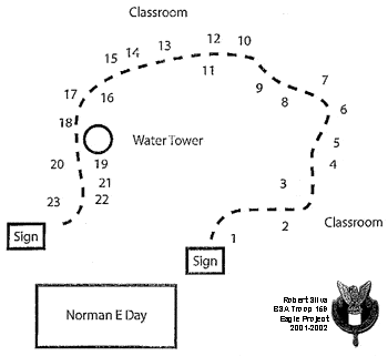
2. Gray Birch Tree
3. Apple Tree
4. Eastern Red Cedar Tree
5. Eastern White Pine Tree
6. Juniper
7. Closed Gentian & Columbine
8. Christmas Fern
9. Quarrying
10. Quarry Tailing
11. White Birch Tree
12. Lady Slipper
13. Partridge Berry
14. Black Oak Tree
15. Red Oak Tree
16. Variegated Pipsissewa
17. Sassafras Tree
18. Witch Hazel
19. Grapes
20. Rattlesnake Plantain
21. Shagbark Hickory
22. Red Maple Tree
23. Lady Fern
Location
The best way to access the trail is by parking in the rear of the Norman E. Day School and locating the trail-head about 150 yards to the right of the bluebird boxes along the scrub brush. The trail is wide and easy to follow once it is located.Parking: Ample
Trail Map
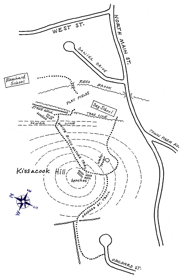
Click to zoom in or out
Topographic Map
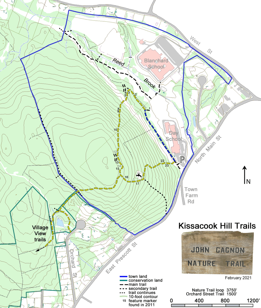
Click to zoom in or out
Difficulty
 Easy
EasyActivities
- Hiking
- Birding
- Wildlife Viewing